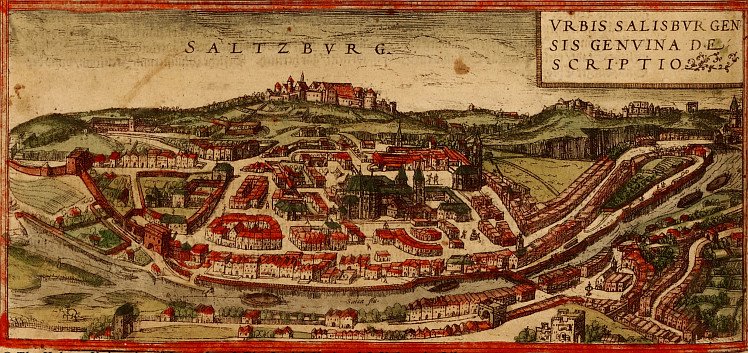
 Saltzburg, Austria
 Vilnius, Lithuania
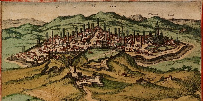 Siena, Italy
 Vienna, Austria
 Moscow
 Barcelona
 Algiers, Algeria
 Marseille
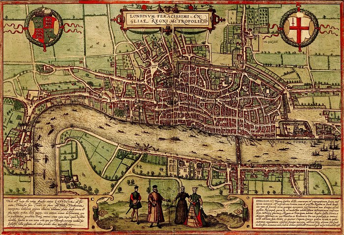 London
"The view of Venice is that of 1565 by Bolognino Zaltieri (fl. 1560-80))—a feast for the eyes reflecting the wealth and architectural richness of the Serenissima. It references 188 buildings, bridges, and areas of the city by number, and it individually identifies many more of the canals, churches, and surrounding islands. Few have changed today. The image is a celebration of the city's political power as much as a spatial guide to its monuments and form. The wide variety of ships in the image underscores Venice's naval and economic dominance in the Adriatic. The political identity of the city is emphasized by the inclusion of a ceremonial procession of the Doge and members of the patriciate Senate of the city, here shown in formal dress, depicted in the center insert in the image's lower panel."
[Click the pictures for larger versions]
Civitates Orbis Terrarum ('Cities of the Earth') is a mammoth 5 volume publication of over 540 city maps (mainly in Europe), released to great popularity between 1572 and 1617. The principal editor was Georg Braun and among the 100 people involved in its production, Belgian Frans Hogenberg did most of the engraving work.
Jovis Hoefnagel (and later his son Jacob) provided the bulk of the birds-eye city drawings but there were many sources used. Abraham Ortelius, who produced the first world atlas, was both an inspiration and practical advisor for the Civitates Orbis Terrarum project. Indeed, Hogenburg had engraved most of the plates in Ortelius's groundbreaking 1570 Theatrum Orbis Terrarum.
Interestingly, Braun mentions in Volume 1 that the human figures seen in many of the maps were added not so much as a popularizing embellishment, but as a precaution to prevent the Turks from acquiring military secrets. Their religion forbade them from gazing on depictions of people...or so the story goes.
The maps in fact invite quite a depth of historical scholarship - there is a geospatial accuracy in relation to much of the architecture and city planning, fortifications as they actually existed are included, the costumes of the people are themselves source material and an overall sense of the economic and trade status of these urban centres can be inferred.
- The Israeli site, Historic Cities, have a large number of multiple resolution images from Civitates Orbis Terrarum online. I think I would want to check some other sources regarding background detail on general principles however. They have sourced their images from the Hebrew University of Jerusalem and the Jewish National & University Library.
- The Gun Powder, Compass and Printing Press Oxford University course material website have a small number of images available with zooming capability (some interesting things in that site).
- In Prayse of the Needle have some scans of costumes taken from English city maps (another interesting site to look around - historical inspired needlework)
 On a completely different note, if you haven't come across the Coudal Partners website before, go check it out, including their MoOM. Despite my making guest contributions there this month, it's a great site.
UPDATE 2010: (essentially seems to be the same as above as far as I've looked) -- Braun, Georg; Hogenberg, Franz; Novellanus, Simon Beschreibung vnd Contrafactur der vornembster Stät der Welt (Band 1) at the University of Heidelberg.


4 comments :
I've always loved looking at maps, especially old ones, especially city plans. These are beautiful, thank you.
Oh...My....Gosh.....these are breathtaking. Thank-you! What a great resource to show my students about early mapmaking. I love and appreciate the work you are doing here.
Apparently, the guy who might have been the artist of the Codex Maggi that I wrote about recently, Lodewijk Toeput, aka Ludovico Pozzoserrato, was an acquaintance of Joris Hoefnagel, and was involved in the Civitates project to some extent. I couldn’t decode the Russian in your link, although I did at least discern one word: блог!
Cheers!
It decodes well in babelfish and is actually a russian LJ illustration entry heading. I just thought I'd point them elsewhere. I wonder if they saw it..?
Post a Comment
Comments are all moderated so don't waste your time spamming: they will never show up.
If you include ANY links that aren't pertinent to the blog post or discussion they will be deleted and a rash will break out in your underwear.
Also: please play the ball and not the person.
Note: only a member of this blog may post a comment.