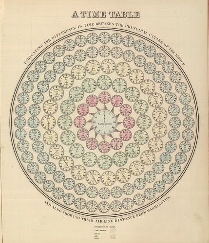
A time table indicating the difference in time between the principal cities of the World and also showing their air-line distance from Washington.
IN: 'Mitchell's New General Atlas, Containing Maps Of The Various Countries Of The World, Plans Of Cities, Etc., Embraced In Ninety-Three Quarto Maps, Forming A Series Of One Hundred and Forty-seven Maps and Plans, Together With Valuable Statistical Tables..' by Samuel Augustus Mitchell Jr, 1883; published in Philadelphia by WM Bradley.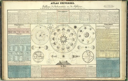
Tableau d'Astronomie et de Sphère
IN: 'Atlas Universel d'Histoire et de Geographie Anciennes et Modernes, de Mythologie, des Religions, d'Astronomie, de Physique, de Geologie, de Histoire Naturelle, de Grammaire, de Rhetorique..' by Henri Duval, 1834; published in Paris by L Houbloup.
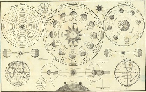
Tableau d'Astronomie et de Sphère [detail]
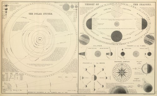
The Solar System. Theory of the Seasons.
IN: 'General Atlas Of The World: Containing Upwards Of Seventy Maps. Engraved On Steel, In The First Style Of Art, By Sidney Hall, William Hughes, F.R.G.S., &c. New Edition. Embracing All The Latest Discoveries Obtained From Government Surveys And Expeditions, Books Of Recent Travel, And Other Sources, Including The North-West Passage Discovered By H.M. Ship Investigator. With Introductory Chapters On The Geography And Statistics Of The Various Countries Of The World, And A Complete Index Of 65,000 Names' by Adam & Charles Black, Sidney Hall and William Hughes, 1854; published in Edinburgh by A & C Black.
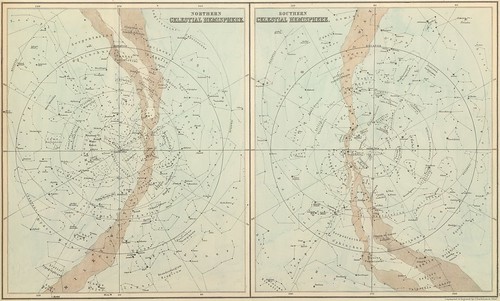
Northern Celestial Hemisphere. Southern Celestial Hemisphere.
IN: 'General Atlas Of The World: Containing Upwards Of Seventy Maps...{as above}' by Adam & Charles Black, Sidney Hall and William Hughes, 1854; published in Edinburgh by A & C Black.
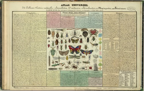
Tableau d'Histoire Naturelle: Annelides, Crustaces, Arachnides, etc.
IN: 'Atlas Universel d'Histoire et de Geographie anciennes et modernes, de Mythologie, des Religions, d'Astronomie, de Physique, de Geologie, de Histoire naturelle, de Grammaire, de Rhetorique &..' by Henri Duval, 1834; published in Paris by L Houbloup
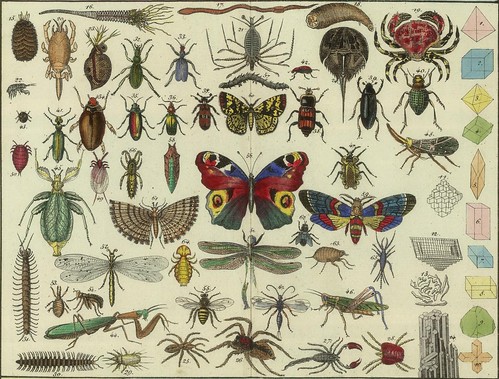
Tableau d'Histoire Naturelle: Annelides, Crustaces, Arachnides, etc. (detail)
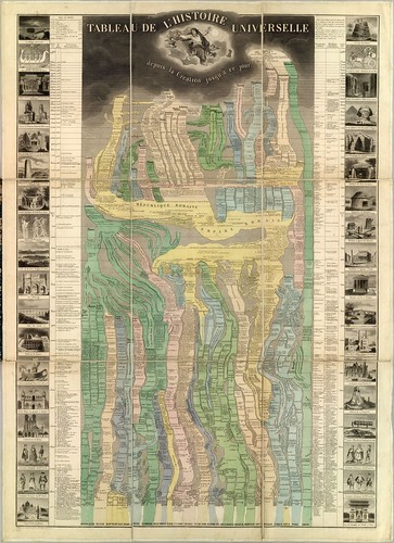
Tableau De L'Histoire Universelle depuis la Creation jusqu'a ce jour
This is a fold-out print depicting all of human history from the time of creation (4693 BC = Adam & Eve; the great flood = 3300 BC) up to the date of publication (1858 by Eug. Pick, Paris). Vignettes of historically significant people, places and buildings etc are arranged along the borders.
This audacious document mirrors the style of a similar graphical print by Colton from 1842 [I don't think it's online] and is in the same ballpark as an 1836 chart by Emma Willard (see here).
The designer has employed something of a metaphorical display choice: civilisations are presented as a series of rivers -- the widths likely imply the comparative population level of each group versus the world's population -- which 'flow' down through history.
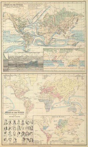
Chart of the World Exhibiting Its Chief Physical Features. Currents of the Ocean &c. Ethnographic Chart of the World Shewing (sic) the Distribution and Varieties of the Human Race.
IN: 'General Atlas Of The World: Containing Upwards Of Seventy Maps...{as above}' by Adam & Charles Black, Sidney Hall and William Hughes, 1854; published in Edinburgh by A & C Black.

Topographical Atlas Of The City Of New York Including The Annexed Territory. Showing original water courses and made land.
[click here for a VERY large version - the version at the source site is two or three times as large again: the downloadable MrSID file is ~50Mb which converts to a 270+ Mb jpeg file--> source]
Another stand-alone print, produced by J Bien & EL Viele in 1874 (by photolithography).
"Includes graphic scale. Streets named, ferry routes shown, railroads, streamcourses designated, and topography shown by hachures. Lands designated as originally meadow or marsh, or water as shown as made (filled) lands. Includes Manhattan and the Bronx and adjacent islands. Shows three cross-sections: across Central Park, from 50th Street to Brooklyn Heights, and from Hoboken to Brooklyn."
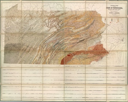
Geological Map Of The State Of Pennsylvania
'Geological Map Of The State Of Pennsylvania, Constructed From Original Surveys Made between the Years 1836 and 1857, Under The Superintendence Of Henry D. Rogers, State Geologist. To Accompany the Final Report on the Geological Survey of the State 1858. Entered ... 1858 by Henry D. Rogers ... Pennsylvania. Engraved by W. & A.K. Johnston Edinburgh.'
The different colours refer to the various geological types (coal = grey shades for instance). The bottom of the chart includes cross-sectional geological views of numerous land tracts.
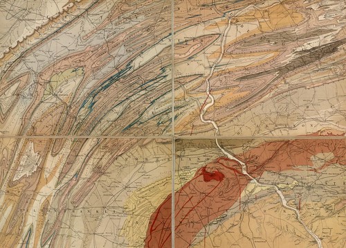
Geological Map Of The State Of Pennsylvania [detail]
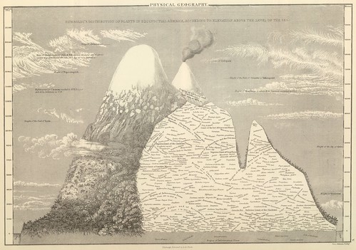
Humboldt's Distribution of Plants in Equinoctial America
IN: 'General Atlas Of The World: Containing Upwards Of Seventy Maps...{as above}' by Adam & Charles Black, Sidney Hall and William Hughes, 1854; published in Edinburgh by A & C Black.
Alexander von Humboldt's original (and exceptionally clever, for the time) botanical elevation distribution map of Ecuador's Mount Chimborazo appeared in the first decade of the 19th century [see: here/here and wiki. Humboldt is the first of my heroes to be mentioned in this post.]
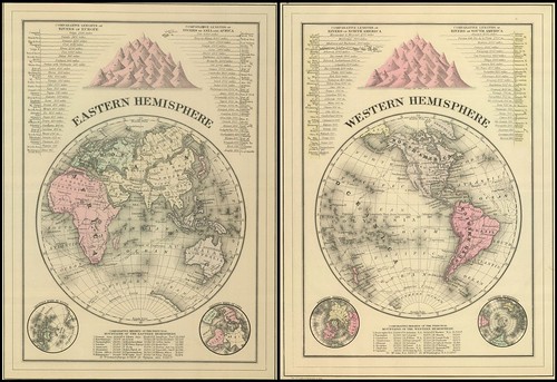
Eastern and Western Hemispheres (two separate pages joined for this image)
IN: 'Mitchell's New General Atlas, Containing Maps Of The Various Countries Of The World, Plans Of Cities, Etc., Embraced In Ninety-Three Quarto Maps, Forming A Series Of One Hundred and Forty-seven Maps and Plans, Together With Valuable Statistical Tables..' by Samuel Augustus Mitchell Jr, 1883; published in Philadelphia by WM Bradley.
Includes inset drawings at the top showing comparative river lengths and mountain heights plus inset globe maps of the greatest masses of water and depictions of the southern and northern hemispheres at the the bottom.
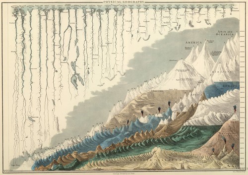
Tinted drawing showing the comparative lengths of rivers and heights of mountains worldwide. The first text page in this volume has the legend for this sheet.
IN: 'General Atlas Of The World: Containing Upwards Of Seventy Maps...{as above}' by Adam & Charles Black, Sidney Hall and William Hughes, 1854; published in Edinburgh by A & C Black.
***Be sure to check out the River Deep Mountain High post from last year for lots more comparative graphics from the 19th century.***
-----------------------------------------------
The David Rumsey Map Collection has now been online for ten years. The above selection of carto-curios is from the latest batch of material uploaded to the site.
Rumsey is an internet hero of the first order. Following the success of his business he was able to afford to indulge his latent interest for all things cartographic and he assembled a massive collection of more than 150,000 items.
That might have been the end of the story: rich dude spends money on secret passion in obscurity. But Rumsey wanted to share his collection with the world and mere donation of his maps and atlases to a document repository didn't seem like it would fully satisfy his magnanimous urges. From a five year old interview on SFGate:
"I realized that whichever institution I gave it to would lock it away, put it on a shelf," he says, with mild indignation. "But just then the technology came along that would enable me to put it all up online, and it was obvious that this was the best way I could give it away to the public."
The site has been in continual development since. Every nine or twelve months a new cache of maps is added and the delivery system has been upgraded and optimised to a point where the site offers an exceptional model for how large-scale digitisation collections can be hosted and served in multiple formats in a very user-friendly manner.
So it goes that the most recent incarnation of the site is now live and is joined by a new blog (here's the announcement post about the newly available material) together with a twitter feed and facebook page.


18 comments :
Very useful, thanks a lot)
I have a wonderful Scientific American guide ca. 1900 that has many of these types of illustrations. It is one of my most treasured books, keep more coming!
Rumsey is our kinda guy. Evidamente.
Many thanks, Pecay! Thank you for this beautiful post, for your Illuminating blog!! for the links. I viewed these wondrous maps with my mouth agape in utter awe. Stunning! Happy merry everything!
Nothing new under the sun eh? Very nice indeed: real artisans!
The Geological Map of the State of Pennsylvania is actually available as an MrSID...the link in the left hand column at the David Rumsey site does work. It's a big MrSID though, 43MB...expands out to 22160 x 17741 pixels...about 1.46GB uncompressed!
Oh right, thanks for that : it wasn't available the 13 or 29 times I tried over a few days!
great infographics..thanks for posting
Really enjoyed that. Thank you for the great post.
so old infographics, thanks for sharing.
Thanks for sharing such a great information. Really amazing time table.
these are great visuals - appreciate the post
Awesome collection, thanks for sharing
The website is very interesting, congratulations and good luck!
These are such remarkable examples of what we know have today in maps and family trees, other forms of graphs and charts. This is the origin. A great gift to share with us all.
Thanks !
genial!
I love these victorian graphs. Thanks for your collection.
Post a Comment
Comments are all moderated so don't waste your time spamming: they will never show up.
If you include ANY links that aren't pertinent to the blog post or discussion they will be deleted and a rash will break out in your underwear.
Also: please play the ball and not the person.
Note: only a member of this blog may post a comment.