


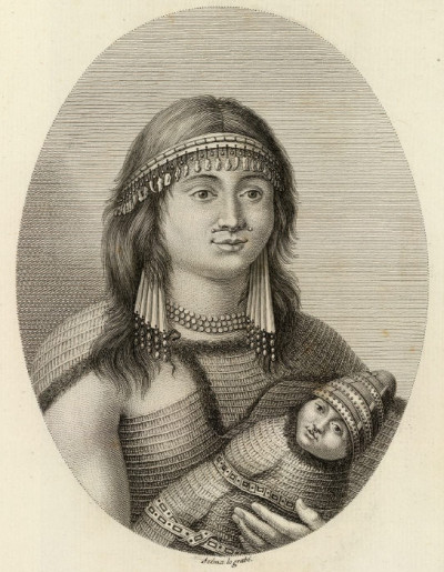
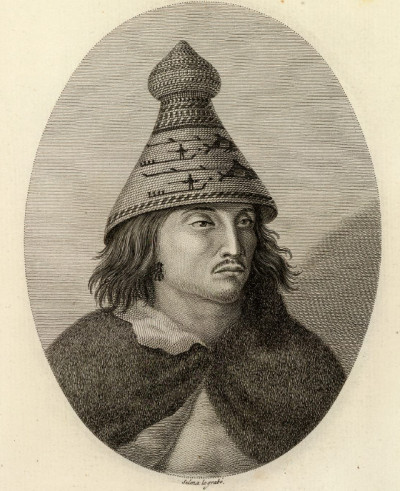
The above images come from: Atlas para el Viage de las Goletas Sutil y Mexicana 'al reconocimiento del Estrecho de Juan de Fuca en 1792', published in 1802 by the author José de Espinosa y Tello de Portugal.
[The portraits are very similar to those posted a few weeks ago from the Cook's Voyage to the Pacific set]
Publication note: The Spanish "Vancouver." Atlas volume only, first edition. Sometimes attributed to Dionisio Alcala Galiano. The title of the text volume is "Relacion del Viage Hecho por las Goletas Sutil y Mexicana en al ano 1792 para reconocer el estrecho de Fuca..." The last and very important voyage up the Pacific coast to be undertaken by Spain is detailed in the nine maps and eight plates of the atlas. Galiano and Cayetano Valdes led the expedition, arriving in the northwest at the same time as Vancouver. Although the maps were published four years after the Vancouver maps, Wagner considers them in many respects to be superior, and Humboldt used them in his Essai Politique sur le Royaume de la Nouvelle Espagne. Wagner further states: "The general impression today...is that the English discoveries of Vancouver were published four years before those of the Spaniards. This...is a misapprehension... The principal reason, however, why the nomenclature and geography of Vancouver came to occupy the field was that his maps were extensively copied by the famous English cartographer, Aaron Arrowsmith, and later by the English Admiralty." "

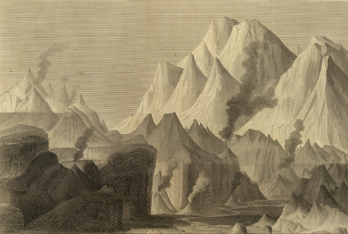
A comparative view of the heights of the principal mountains and other elevations in the World. Drawn & engraved for Thomson's New General Atlas by W. & D. Lizars, Edinburgh. (1817) The engraving includes vertical measurements and names of the peaks.
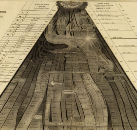
 Picture of Nations or Perspective Sketch of the Course of Empire. Published 1836 in Atlas to accompany a System of universal history; containing, I. A chronological picture of nations, or perspective sketch of the course of empire. II. The progressive geography of the World, in a series of maps, adapted to the different epochas of the history. by the very interesting Emma C. (Hart) Willard, principal of Troy Female Seminary.
[I found this to be an extraordinary image and the detail here hardly does it justice. It was an attempt to outline world history from the time of creation, through the birth of Christ (the obvious star) up to the empire of Napoleon, being the horizontal section at bottom centre of the image. It reminds me of the tree branching cladogram maps in species phylogenetic relationships]

 [The last 2 images I had collected along the way and didn't retrieve any information about them]
Click on the images here for slightly larger versions.
Serendipity was involved in my somehow finding my way (back) to the
fantastic David Rumsey cartographic website.
Last month, another 1500-odd further maps were uploaded to bring the total of high resolution free maps available to over 12,000, out of a personal collection that totals about 150,000 maps.
It was among the new images that I spent way too much time today in collecting the above jpegs. As usual, I was drawn to curios and there are plenty of others that I didn't post. Of course, most of the material online is strictly maps and atlases and they concentrate on the Americas between 1700-1900 for the mostpart, but not exclusively. It will likely require downloading a browser plugin to see the large documents (I'd done so previously, so can't remember what's necessary - nothing too painful anyway)
This profile of David Rumsey is well worth a read. His is a great attitude for anyone who likes to see primary source material available free online.
I am obliged to the custodian of
The Map Room both for pointing me towards the profile of Rumsey but more importantly, from a personal perspective, for announcing and linking BibliOdyssey when it began, for which I am very grateful. If you have any latent or overt cartophilic tendencies, go have a look at
The Map Room. It's aimed at a general audience and is not too technical.


No comments :
Post a Comment
Comments are all moderated so don't waste your time spamming: they will never show up.
If you include ANY links that aren't pertinent to the blog post or discussion they will be deleted and a rash will break out in your underwear.
Also: please play the ball and not the person.
Note: only a member of this blog may post a comment.