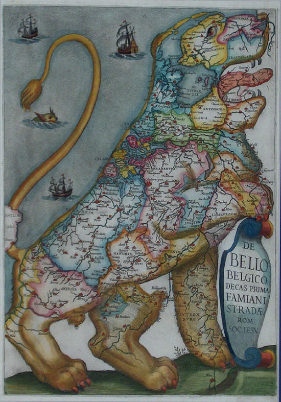
In the annals of medieval/renaissance cartography, the curious fashion of depicting the seventeen provinces of the (then) Low Countries as being part of a lion began in c. 1583. The Austrian Baron, Michael Eitzinger (or Aitzinger or van Aitzing), settled in Cologne after travelling Europe for thirty years and published his History of the Low Countries in his role as historian and cartographer to Emperors Ferdinand II and Maximillian II.
The suggestion for his Leo Belgicus probably derives from almost all of the provinces having a lion in its coat of arms. The initial map proved to be popular and various copies and derivations were published over the next couple of centuries. There were four major variants produced that took into account the permanence of the coastline feature, the changes in political status and the eventual independence gained by Holland. The above map comes from the Jesuit engraver and author Famiani Strada, whose Histoire de la Guerre de Flandres version was released in 1631.
skip to main |
skip to sidebar


analytics
Books~~Illustrations~~Science~~History~~Visual Materia Obscura~~Eclectic Bookart.


Contact | Who?

Recommended Blogs
Blog Archives
Resource Sites
- digital nz
- library of congress
- british library
- library france
- library holland
- library spain
- library portugal
- european library
- library australia
- collections canada
- digital poland
- nypl digital
- botanicus digital
- v&a collections
- britmuseum prints
- smithsonian search
- smithsonian galaxy
- f.a.m.s.i.
- casglu'r tlysau
- rumsey collection
- manuscript catalogue
- digital scriptorium
- cesg manuscripts
- swiss manuscripts
- pecia mss blog
- digital book index
- rare book room
- online exhibitions
- primary sources
- worldcat search
- library directory
- digital librarian
- intute resources
- warburg institute
- lexilogos links
- digiwiki links
- museum blogs
- book arts web
- culture archive
- conservation articles
- art-history timeline
- visual arts
- arts journal
- artcyclopedia
- ukiyo-e
- calligraphy megapage
- penmanship
- woodblock
- coconino
- alchemy website
- health hist. img-banks
- health history links
- history network
- new advent


1 comment :
wow, amazing!
ancient information design of my own region! Cool!
Post a Comment
Comments are all moderated so don't waste your time spamming: they will never show up.
If you include ANY links that aren't pertinent to the blog post or discussion they will be deleted and a rash will break out in your underwear.
Also: please play the ball and not the person.
Note: only a member of this blog may post a comment.