This is one of the finest collections of 17th century cartographical prints and drawings in existence. Joan Blaeu's original 'Atlas Maior' (Great Atlas) from the 1660s was substantially expanded into something of a personal world geo-encyclopaedia in the following decade by the Amsterdam lawyer, Laurens van der Hem, while continuing a visual style established by Blaeu. The gargantuan ~50 volume series -- housed today in the Austrian National Library in Vienna -- includes more than 2400 maps, charts, sketches and birds-eye-views of towns, buildings and harbours, seascapes and landscapes, with the occasional portrait of significant historical figures.
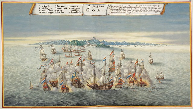
Goa {India}
The Dutch appeared in the Indian waters around Goa in the 17th century and their blockades of the Portuguese territory was responsible for Goa's decline into poverty. Although the colony was never conquered by the Dutch, it became the last remaining city under Portuguese control on the west coast of India. [W]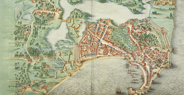
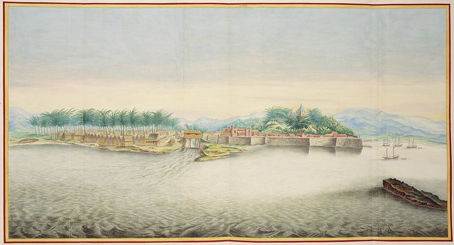
Unnamed fort town
[UPDATE: this is almost certainly Colombo, Sri Lanka. Here's a very similar version from around the same time, by one of the Vingboons (cartographic) family members [search page] Thank Will C!"The history of the Dutch East India Company [or VOC: ‘Verenigde {United} Oostindische Compagnie], founded in 1602 and declared bankrupt in 1799, spans almost the whole of the seventeenth and eighteenth centuries. For much of this time it was the world’s largest trading company, owning, at the height of its wealth and power, more than half the world’s sea-going shipping. [..]
The VOC played not only a key role in the history of the Netherlands, but also in that of the other states in which it was involved, from England, France, Spain and Portugal in Europe, to any number of principalities, sultanates and empires along the coasts of Asia, going as far as Japan and China, and including most of the coasts of India, Ceylon, Malaya and what is now Indonesia, to say nothing of the odd port of call in Africa. The VOC’s operations were entirely maritime, at least in principle, and, until late in the eighteenth century, its ports of call were in no sense part of a Dutch colonial empire." [source]
"It was also arguably the first megacorporation, possessing quasi-governmental powers, including the ability to wage war, imprison and execute convicts, negotiate treaties, coin money, and establish colonies. Statistically, the VOC eclipsed all of its rivals in the Asia trade. Between 1602 and 1796 the VOC sent almost a million Europeans to work in the Asia trade on 4,785 ships, and netted for their efforts more than 2.5 million tons of Asian trade goods. By contrast, the rest of Europe combined sent only 882,412 people from 1500 to 1795, and the fleet of the English (later British) East India Company, the VOC’s nearest competitor, was a distant second to its total traffic with 2,690 ships and a mere one-fifth the tonnage of goods carried by the VOC. The VOC enjoyed huge profits from its spice monopoly through most of the 17th century." [source]
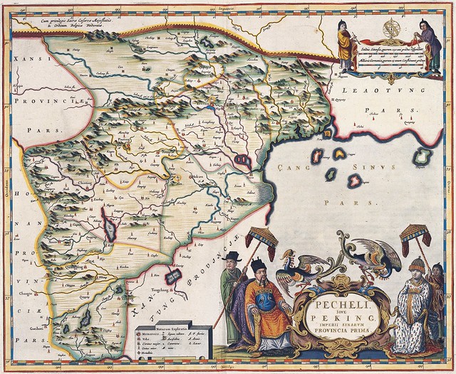
Pecheli sive Peking Imperii Sinarum Provincia Prima
Blaeu produced the first western atlas of China, relying on information and drawings contributed by an Italian Jesuit missionary. Inexplicably, this map* identifies Peking ( the modern Beijing) as 'Xuntien' (perhaps after the earlier 17th c. Merian map, based on Marco Polo's 12th c. accounts)."[Jesuit] Father Martino Martini traveled through the region between 1643 and 1650. This was a period of great internal unrest and his was a perilous journey. He was able to travel inland to the Great Wall and for the first time determined with any scientific accuracy the astronomical position of many cities and topographical features. After establishing a mission in Zhejiang province he returned to Rome via Amsterdam, where he met Joan Blaeu. Blaeu then prepared a group of eight maps covering China in great detail." [source]
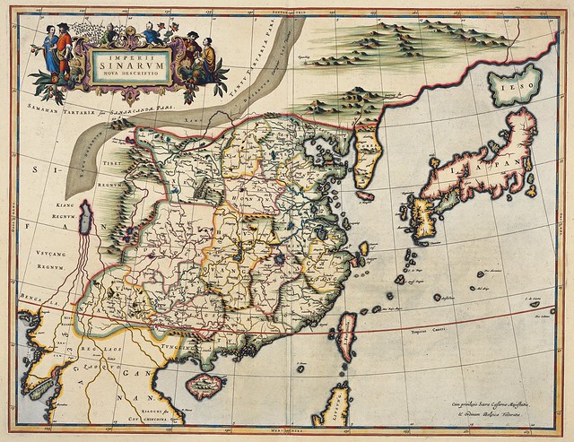
Imperii Sinarum Nova Descriptio
"A important general map of China, Korea and Japan, published by Joan Blaeu in the Jesuit Martino Martini's 'Atlas Sinensis' , the first western atlas of China. The discoveries of Joao de Goma and de Vries were incorporated into this map. Korea is no longer depicted as an island. This is the first map to name and show Hokkaido (Ezo) as an island to the north of Honshu. China is mapped with considerable accuracy for the period: even the Great Wall is shown. Martini was the Jesuit Superior in Hangchow and he collated surveys of all the regions of China which he brought back to Europe in 1654 for printing and publication." [source]
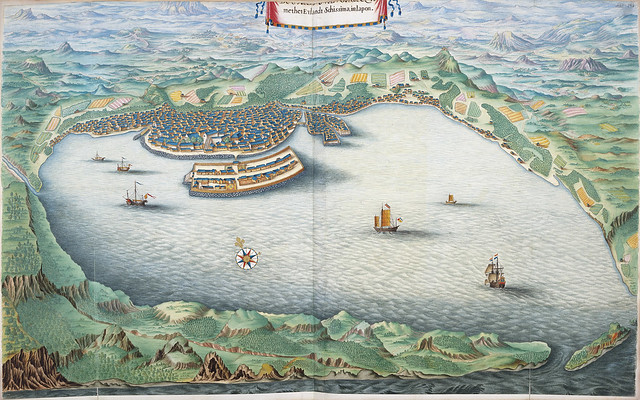
Ee Stadt Nangasacky met het Eylandt Schissima, in Japon
(part of the inscription is missing)
The city of Nagasaki and Dejima Island in Japan
"Dejima [meaning Exit] was an artificial island [completed in 1636] built in the shape of a fan with an area of about 13,000 square meters. It was built south of the current [Nagasaki] city center during the Edo Period in order to accommodate Portuguese Christian missionaries and prevent the propagation of their religion. It also used to be the residential quarters of the Dutch, the only foreigners allowed to trade in Japan during the Sakoku (Isolation) Period, and a Dutch Trading House operated on the island. For 200 years, until Japan reopened the country in the 19th century, Dejima was its only window to the world." [source see also: one | two | three]
Malacca
(a city* [aka: Melaka] and state in (the modern) country of Malaysia)
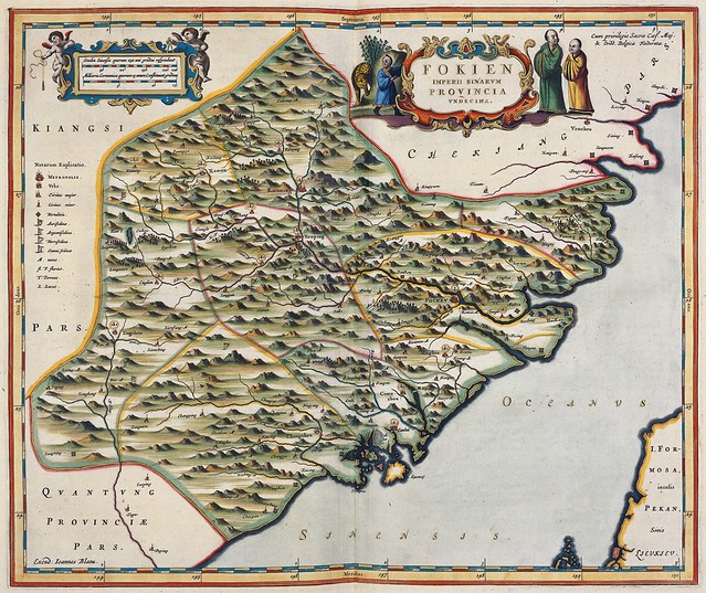
Fokien Imperii Sinarum Provincia Undecima
Another Martino-Blaeu collaborative map. Fokien (Fujian) province* in China is shown opposite the tip of the island of Taiwan (the location/orientation is somewhat incorrect). The mainland map stretches from Whenzhou in the north to Fuzhou in the south.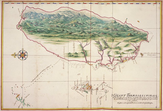
Eijlant Formosa Generael
The contours of Formosa [Taiwan] and the Piscadores islands (in the south) on this map are identical to those in the Vingboons Atlas [this]. 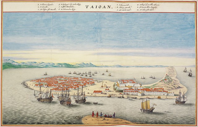
Taioan
Bird's eye view of Tayouan [Taiwan] and Fort Zeelandia*. The survey image
includes a legend identifying government buildings, markets, neighbourhoods etc.
Unnamed island
About the Atlas Blaeu-Van der Hem: -- "When the Latin edition of Joan Blaeu's 'Atlas Maior' was published in 1662, Laurens van der Hem (1621-1678) acquired a copy which he used as the base for an even more ambitious collection of maps, topographical drawings and prints.
Van der Hem arranged the sheets in the Atlas according to his own ideas, amplifying the volumes with more than 1800 maps, charts, townscapes, architectural prints, portraits, etc., many of them beautifully coloured by the well known specialist Dirck Jansz. Besides prints, the atlas also contains a wealth of drawings: maps, town and seascapes, renderings of foreign people etc. To enhance the harmony and unity of the whole, all the sheets were adapted to the size of the 'Atlas Maior'. If they were too wide, they were folded in; if they were too small, they were enlarged, and coloured in such a way that the transition from original print to enlargement became invisible; if the original sheets were too high, they were reduced in format, or cut into pieces, and separately pasted on blank leaves.
Among the most impressive of Van der Hem's additions to the 'Atlas Maior', is the set of four volumes of manuscript-maps and topographical drawings, which were originally made for the VOC (Dutch East India Company). These volumes are known as the *secret atlas of the VOC*. Van der Hem was one of the few private citizens to possess part of this confidential material. Other well known additions to the 'Atlas Maior' include the extensive series of topographical drawings, the majority of which was done by well known artists such as Willem Schellinks, Lambert Doomer, Jan Hackaert, and Reinier Nooms called Zeeman. Thus Van der Hem created an atlas which far extended the scope of Blaeu's original 'Atlas Maior'.
The 'Atlas Blaeu-Van der Hem' contains an inestimable treasure of information, not only in the fields of geography and topography, but also in those of archaeology, architecture, sculpture, ethnography, folklore, heraldry, navigation, fortification and warfare, portraits of famous figures, techniques, public works, and many other aspects of seventeenth-century history, culture, and customs. Moreover, all this information is conveniently arranged in a unified manner. As one scholar put it: "the Atlas is a mirror of the geographical and geopolitical knowledge, available in one of the major trading-nations of the world in those days" [source]
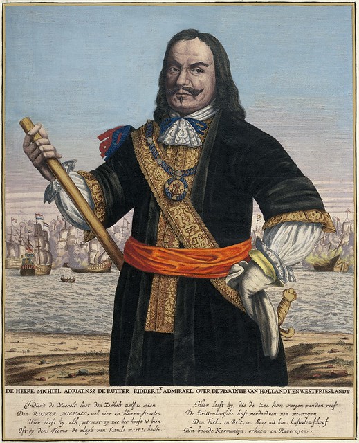
De Heere Michiel Adriatnsz De Ruyter Ridder Lt Admirael
Over De Provintie Van Hollandt En Westfrieslandt {b&w version}
Michiel Adriaenszoon de Ruyter is the most famous, and one of the most
skilled, admirals in Dutch history, and is particularly renowned for
his role in the Anglo-Dutch Wars of the 17th century. [W]
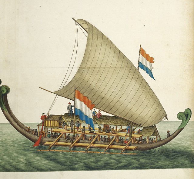
Dutch outrigger
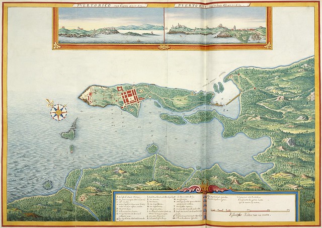
Puerto Rico
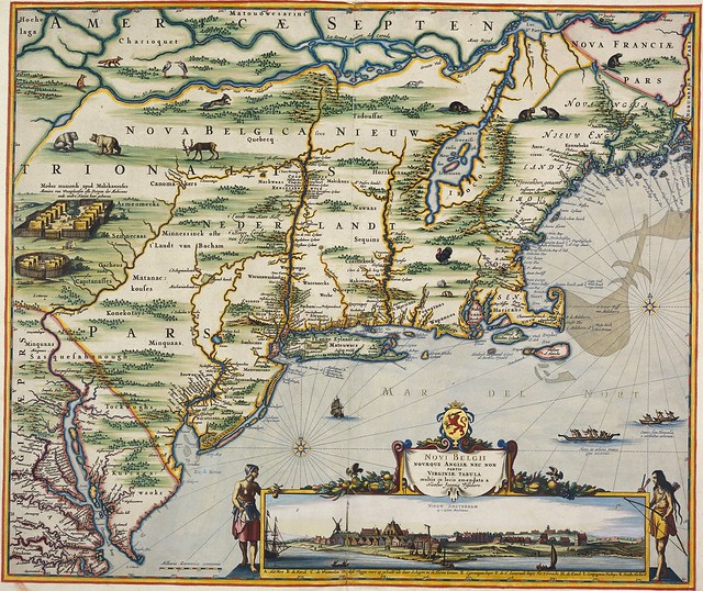
Novi Belgii Novaeque Angliae Nec Non Partis Virginiae Tabula
(by Nicolaes Visscher)
"The map [..] included present day New England as well as New Jersey, New York, and Maryland and combines both Dutch and Indian place names. Scattered throughout the map are depictions of native flora and fauna: herons, beavers, wild turkeys, deer, rabbits, bears, muskrats, foxes, and wolves. Stockaded settlements and dugout canoes represent the Indian presence. At the bottom of the map is a striking inset view of New Amsterdam showing period houses, ships in the harbor, a windmill, and even a gallows! To either side of the inset are two female Indian figures, allegorical representations of America. [..]
During the seventeenth century, the Dutch produced both accurate and decorative maps that exemplified the Golden Age of cartography as demonstrated by the Jansson : Visscher series of maps depicting New England. While Jan Jansson's 1651 map entitled "Novi Belgii" is considered to be the first in the series, inaccuracies in the map led Claes Visscher to publish an updated map of the same title around 1655." [source] {See: large zoom/jpeg version of this map at Harvard U}
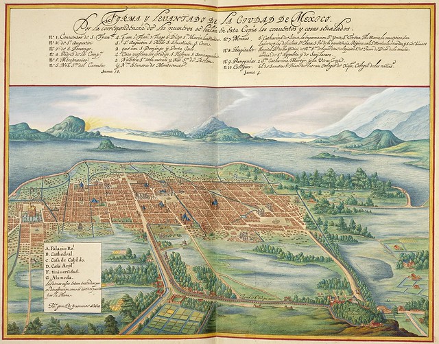
Forma y Levantado de la Ciudad de México
(Plan and elevation of Mexico City [looking East})
This is an identical copy of the original 1628 watercolour drawing (see here) sketched by the Spanish-Mexican architect, Juan Gómez de Trasmonte. His picture was made as a survey to prepare for expected flooding and was never meant to be published. (Trasmonte designed Mexico City's cathedral)
Pascaart vande Parsiaense Kust
Map of the north coast of the Persian Gulf
Qeshm is an Iranian island situated in the Strait of Hormuz*
and the island fort is painted here as an inset
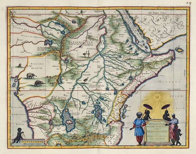
Aethiopia Superior vel Interior vulgo Abissinorum
sive Presbiteri Joannis Imperium
NE Africa by Joan Blaeu [see zoom version] after his father,
Willem Janszoon Blaeu (his sources are listed below)
"The map shows a major section of central and eastern Africa including Mozambique north to present day Sudan. The map contains numerous rivers, villages and settlements throughout, and is highly embellished with elephants, ostriches and other animals within the map, as well as the decorative cartouche. The two Ptolemaic lakes of Zaire and Zaflan are in the lower portion of the map. Lake Niger, and the supposed course of the Niger River, is shown flowing westward.
This map is based on Ortelius' map of Prester John of 1573. The myth of Prester John, the good Christian King of Africa waging his own crusade and defeating the enemies of Christianity, was based upon earlier legends of the Crusaders and is a fascinating piece of early mythological cartographic history." [source]
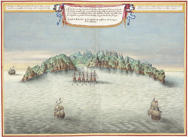
View of the island of St. Helena* showing the Dutch fleet.
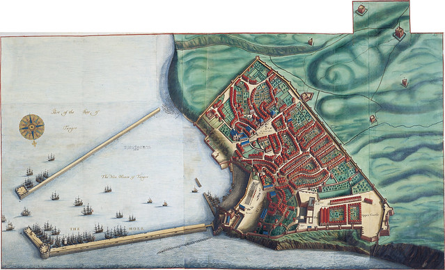
Bay of Tanger
(Bay of Tangier*, Morocco)
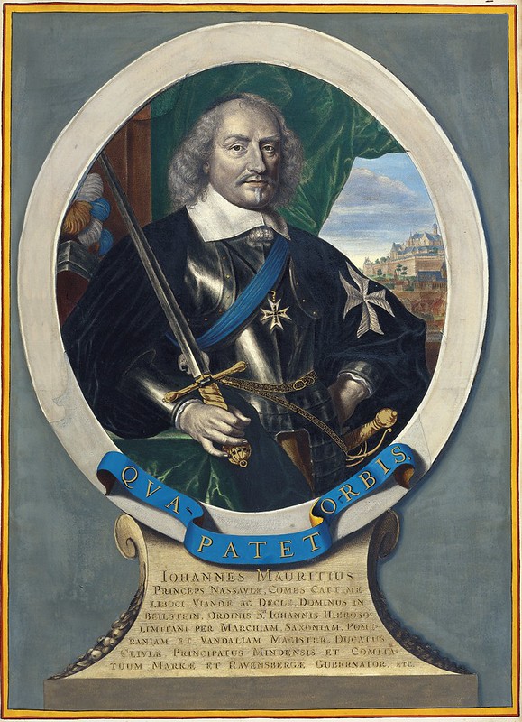
Johannes Mauritius
I believe this to be John Maurice, Prince of Nassau-Siegen (d. 1679)
- appointed governor of the Dutch possessions
in Brazil in 1636 by the Dutch West India Company
[The island nation of Mauritius (below), located in the Indian
Ocean, was named after Maurice, Prince of Orange (d. 1625)]
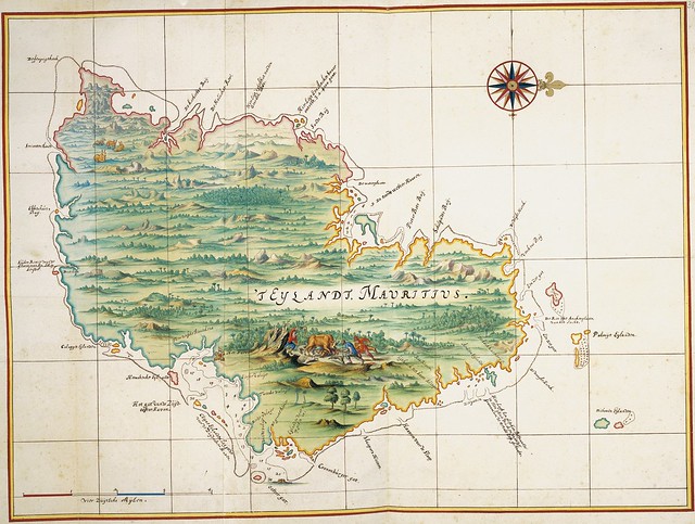
Mauritius*
Note that the illustrated scene in the southern section of
the island shows a man being crushed during a buffalo hunt
In 2011, the Dutch firm, Hes & De Graaf, completed publication of an 8-volume facsimile edition of the 'Atlas Blaeu-Van der Hem'. The exquisite series is accompanied by a final volume:
"[It] contains contributions by Roelof van Gelder on the Atlas of Laurens van de Hem and his library, a detailed description of the life and works of the collector and the making of his Atlas; Truusje Goedings on the coloration of the Atlas; Erlend de Groot on the art historical aspects of a series of drawings from the Atlas; Peter van der Krogt on the Atlas Maior by Blaeu, which served as the point of departure for the Atlas; Benjamin Schmidt on the printed maps from the Atlas, and Dick Gaasbeek on the making of the facsimile of the Atlas, including a detailed description of the photography, the printing and the binding. Together with an introduction by Günter Schilder, this book further contains a catalogue with the numbers and titles of, and brief information on all the maps and images present in the 8 volumes of the facsimile."
- All the images above were sourced (with permission) from Hes & De Graaf's dedicated website for the 'Atlas Blaeu-Van der Hem'. The full series with an optional hand-made wooden storage cabinet was on sale for around the €80,000 mark.
- The Atlas of Mutual Heritage is a great, comprehensive site (if a tad idiosyncratic or, at least, unique) for maps relating to the Dutch East India Company (VOC).
- Explokart Research Project The Atlas Blaeu-van der Hem by Peter van der Krogt and Erlend de Groot.
- Biography of Joan Blaeu at the National Library of Scotland.
- Youtube trailer for a documentary on 'Atlas Blaeu-Van der Hem'.
- Map images by Willem & Joan Blaeu at Wikimedia.
- Blaeu's 'Atlas Maior' : Amazon | Taschen.
- A €25 brochure on the 'Atlas Blaeu-Van der Hem'.
- An earlier (very different) version of 'Atlas Blaeu-Van der Hem' for >€3000.
- 'V.O.C: A Bibliography of Publications Relating to the Dutch East India Company: 1602-1800' by John Landwehr, 1991.
- The 'Atlas Blaeu-Van der Hem' has been entered by UNESCO into the Memory of the World


5 comments :
Nice
"Alzado" instead of "Levantado", dear PK. Greetings from la ciudad de México.
Maybe it's the correct language choice, but the written title does include the word 'Levantado'.
You refer to an unnamed fort in Sri Lanka. When I saw the map I was reminded of Galle where the VOC had a strong presence. However both Colombo and Galle are on the west coast and there would seem to be a sea to the east. Maybe it is Trincomalee. There were many Dutch forts in Sri Lanka. You can still see the remains of one on Delft Island in the north west. Marielise
Thanks Marielise. I spent a few months in Sri Lanka so, although I would never say I'm any sort of geographical or military expert, I was very aware, for instance, if Galle, of the fort (it's one of the big attractions of the town, tourist-wise). Not that I care too much about such things as a passerby. I prefer the people, culture, food & beaches in fact.
The sketch above DOES resemble Colombo, but you still might be right. I bought a motorcycle and *tried* to make it to the East coast, but there were still too many military check-points at the time, although I did run through a couple of them and was pretty lucky not to be locked up.
In any event, and now near-totally changing the subject, I always feel obliged at the mere mention of |Sri Lanka| to advise that, in my humble opinion, the Singhalese are among the friendliest people on earth and despite the 'troubles', it is a destination to which I would return in a heartbeat, if the stars and my wallet were ever to (re-)align. *sigh*
Post a Comment
Comments are all moderated so don't waste your time spamming: they will never show up.
If you include ANY links that aren't pertinent to the blog post or discussion they will be deleted and a rash will break out in your underwear.
Also: please play the ball and not the person.
Note: only a member of this blog may post a comment.