Tuesday, June 30, 2009

Satirical Maps

An Incomplete Evolution
of the Cartoon Political Map
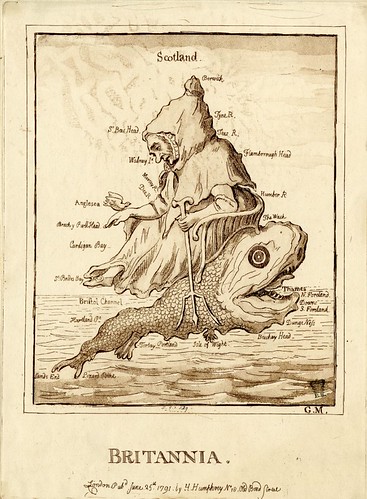


Britannia by James Gillray, 1791

'Britannia'

Etching by James Gillray; published in London by Hannah Humphrey in 1791

Image source: British Museum
"A comic map of England formed by an old woman seated in profile to the left on the back of a dolphin-like monster, whose open mouth (right) represents the 'Thames', the two points of its tail being 'Lands End' and 'Lizard Point'. She holds a trident in her left hand. Her right hand (on which is a dove) and right foot form the north of Wales and the north of the the Bristol Channel. The peak of her cap is 'Berwick'. Many other names are inscribed round the coast. The sea forms a background."
Wright & Evans, in their 1851 book, 'Historical and Descriptive Account of the Caricatures of James Gillray', describe 'Brittania' thus:
"A rather ludicrous burlesque on the map of Great Britain, the work of some amateur artist, and etched by Gillray."


Geography Bewitched or a droll caricature map of Ireland, 1793 (Dighton)

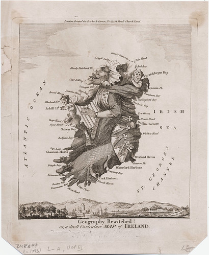
'Geography Bewitched or, a Droll Caricature Map of Ireland'

Designed by Robert Dighton; published in London by Bowles & Carver in 1793

Image source: British Museum


Geography Bewitched or a droll caricature map of Scotland 1794

'Geography Bewitched or, a Droll Caricature Map of Scotland'

Designed by Robert Dighton; published in London by Bowles & Carver in 1793

Image source: Wikimedia


Geography Bewitched or a droll caricature map of England and Wales (after Dighton), 1793

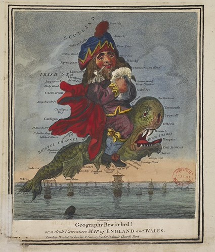
'Geography Bewitched or, a Droll Caricature Map of England and Wales'

Designed by Robert Dighton; published in London by Bowles & Carver in 1793

Image source: British Museum

Robert Dighton was well known as a portrait artist and is regarded as one of the most talented social caricaturists of the late 18th and early 19th centuries. He also achieved notoriety as a thief of valuable prints from the British Museum which he sold on the open art market to supplement his income from painting and etching. Ironically, many of Dighton's original drawings and print illustrations can be now be found in - you guessed it! / (obvious) - the British Museum Prints Room.


The French Invasion, or John Bull, bombarding the Bum-boats, 1793 (Gillray)

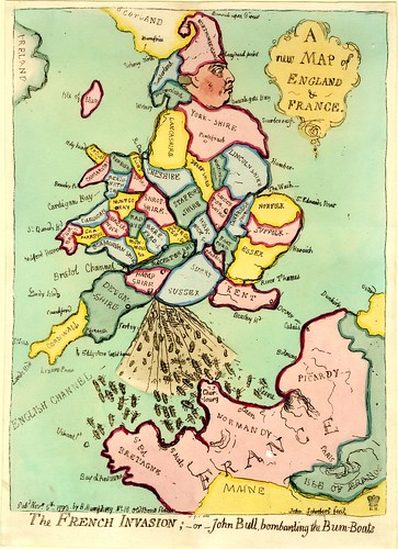
'The French Invasion, or John Bull, bombarding the Bum-boats'

Etching by James Gillray; published in London by Hannah Humphrey in 1793

Image source: British Museum

"A comic map, inscribed 'A new Map of England & France', actually showing England and Wales, the SW. corner of Scotland, the north of France, just including 'Paris', and the Belgian coast as far as Ostend. England is represented by the body of George III (John Bull), his head in profile to the right, wearing a fool's cap composed of 'Northumberland'. His left leg is drawn up, Norfolk forms the knee, the mouth of the 'River Thames' the ankle, Kent the foot. His outstretched right leg terminates as Cornwall.

From the coast, at the junction of 'Hampshire' and 'Sussex', issues a blast of excrement inscribed 'British Declaration', which smites a swarm of 'Bum-Boats' extending from Ushant to the mouth of the Seine. The map is divided (inaccurately, and with omissions, but with a rough correctness) into counties, Wales representing the flying coat-tails of the King, who strides across the ocean with great vigour."


A Whimsical Sketch of Europe, 1806

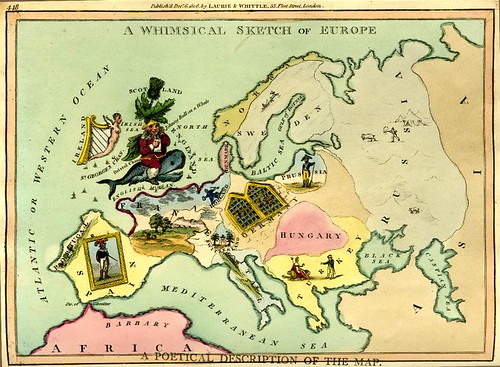
'A Whimsical Sketch of Europe'

Published in London by Laurie & Whittle in 1806

Image source: British Museum

"Great Britain is an adaptation of [the Gillray print above] inscribed 'Johnny Bull on a Whale'; a thistle growing out of his head represents 'Scotland'; an Irish harp is 'Ireland'. The contour of Europe is roughly correct; on most of the countries are little figures or scenes. On 'France' a landscape (torn). On 'Spain' a whole length portrait of (?) Charles IV, hanging askew. On 'Switzerland' a funeral urn flanked by yews. On 'Portugal', as on 'Italy', a landscape. On 'Holland' a Dutch toper. On (west) 'Germany' crowned heads looking out through prison bars. On 'Prussia' is an infantry soldier. On 'Sweden' a reindeer sledge; 'Norway' and 'Denmark' are blank. On 'Russia' are polar bears, &c. In 'Turkey' a Turk advances towards Britannia, who is seated, with cap of Liberty, Lion, and olive-branch. Below [not seen]:

'Oft we see in the shops, a print set up for sale,
England colour'd, an old fellow striding a whale:
Yes! Old England's a picture, the sea forms its frame,
And Hibernia and Scotia they class with the same. "


Komische Karte des Kriegsschauplatzes 1854

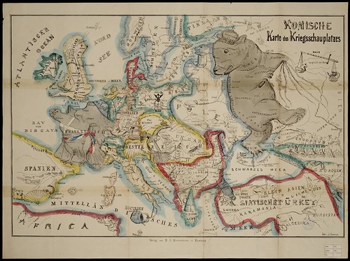
'Komische Karte des Kriegsschauplatzes'
or
'Europa aus der Vogelschau'

(Comical Battlefield Map or Birds-Eye View of Europe)

Published in Hamburg by B.S. Berendsohn in 1854

Image source: University of Amsterdam
"A bibliographically unknown caricature map of Europe showing the political situation of the Crimean War. The Russian Bear, wearing the Imperial crown labeled “Despotism” and branding a cat-o-nine-tails whip strides eastward but looks westward over its shoulder toward an enslaved, chained Polish maiden on her knees. The region labeled “Engentliches Russland” (The Real Russia) is marked Verrath (Teason), Bigottery (Bigotry), etc. The toes of the Russian bear’s right foot take the form of the Crimean peninsula where the French and English fleets gather to “clip the bear’s claws”. The Treaty of Paris, March 1856 concluded the Crimean War and forbade Russia to maintain a fleet in the Black Sea." [source]


Humoristische-oorlogskaart, 1870

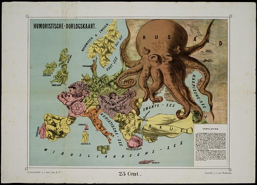
'Humoristische-oorlogskaart'
(Humorous War Map)

Published in Haarlem by J.J. van Brederode in 1870

Image source: University of Amsterdam


Das heutige Europa, 1875

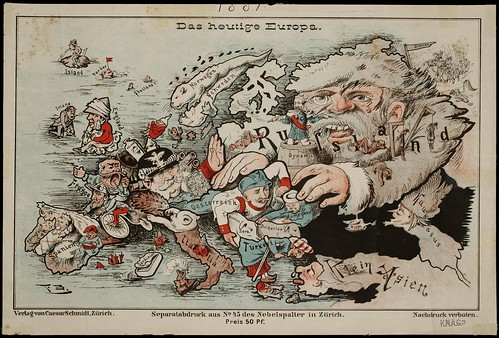
'Das heutige Europa'
(Today's Europe)

Published in Zurich by Caesar Schmidt in 1875

Image source: University of Amsterdam


L'Europe Animale - Physiologie Comique, 1882

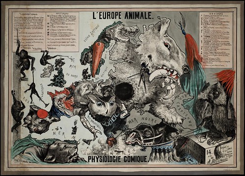
'L'Europe Animale - Physiologie Comique'
(The European Animal - Comical Physiology)

Designed and drawn by A. Belloquet; published in Brussels by Vincent in 1882

Image source: University of Amsterdam


Angling in troubled waters, 1899

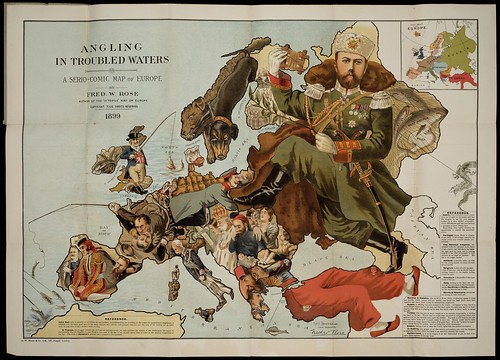
'Angling in Troubled Waters: a Serio-Comic map of Europe'

After the design of Fred W Rose; published in London by GW Bacon in 1899

Image source: University of Amsterdam

(I've posted a version of this map before but this is a much better and larger image)

Re: Fred W Rose (but not specifically about the above map) -

"Caricaturist Fred W Rose created [..] this cartoon map in 1877, when British hostility to Russian territorial ambitions in the Balkans, at the expense of the tottering Ottoman Empire, were at its height. [..] British determination to resist what were held to be Russia's overweening territorial ambitions was not confined solely to India.

The Balkan crisis of 1877, in which the British government sided with the Ottoman Turks against the Russian tsar, led to the publication of a curious Serio-Comic War Map by the noted Victorian graphic artist and caricarturist Fred W Rose. It illustrated the threat posed to British interests by the Russian octopus in its quest for world domination. Rose continued to produce eyecatching cartographical curiosities for the rest of the century, including what was probably his masterpiece, 'Angling in Troubled Waters: A Serio-Comic Map of Europe' in 1899."


John Bull and his Friends by Fred W Rose, 1900

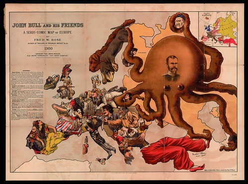
'John Bull and his Friends
A Serio-Comic Map of Europe'

After a design by Fred W Rose; published in London by GW Bacon in 1900

Image source Centre Excursionista de Catalunya (Memòria Digital de Catalunya) [previously]

"Great Britain - John Bull has been attacked by two wild cats. He is however able to rely on the stores of ammunition behind him, as well as his own pluck and great resources. The letter at his feet from his friend Uncle Sam, would be more encouraging were it not for the post-script. The Nationalist section in Ireland has taken this opportunity to vent his abuse upon him, but is restrained by the loyalty of the people.

France too, is scolding and threatening to scratch with one hand, while with the other she is beckoning on Germany to help her. Although the Dreyfus affair is thrust into the back-ground she is much occupied with her new doll's house. She has somehow managed to break all the toys on her girdle and her heart is sore, for she attributes these disasters to John Bull.

Holland and Belgium are also calling him unpleasant names.

Spain, weary with her recent struggles, remembers that John was in no way inclined to help her, and looks up hoping to see him attacked by some of her neighbours.

Portugal is pleased to think he holds the Key of the situation.

Norway and Sweden though still struggling to get free from their mutual leash, turn their attention to John's difficulties, while Denmark is kindly sending him a present of provisions.

Austria and Hungary will be content with dreadful threats

Switzerland's satisfaction that her Red Cross has done good service, is marred by the news of John's victories, which she is reading.

Italy alone holds out the hand of encouragement to his old friend.

In Corsica the shade of her great departed son is wondering why people don't act, as he would have done, instead of growling and cursing.

Turkey, resting comfortably on his late foe Greece, is smiling at the thought that these troubles do not harm him and perhaps he is not sorry that John will not come to much harm.

Russia, in spite of the Tzar's noble effort to impress her with his own peaceful image, is but an octopus still. Far and wide her tentacles are reaching. Poland and Finland aleady know the painful process of absorption. China feels the power of her suckers, and two of her tentacles aer invidiously creeping towards Persia and Afghanistan, while another is feeling for any point of vantage where Turkey may be once more attacked."
"Fascinating political caricature map by Frederick Rose of the countries of Europe, known as the Octopus Map from the brooding presence of the Russian Empire depicted as a massive octopus, whose tentacles stretch out towards Europe. China is shown in the grasp of Russia, as is Persia and Poland. France and Spain are attractive women, while Germany, Italy and England are Military commanders. his map, by Rose, followed the style created by a Frenchman, Joseph Goggin, showing Russia as an octopus."

[All the University of Amsterdam images were spliced together from 20+ screencaps. They are linked through to large versions, but note that very large images were uploaded to Flickr in which all the map text should be legible. However, the Flash zoom module at the source site provides the highest resolution views.]


I think I'll refrain from providing additional commentary on this occasion, save for noting that the above array of maps are a sampling and not intended as a comprehensive visual timeline arrangement. Many important examples are missing (some are scattered through the archives here) and this selection only covers one century of a tradition that probably dates back to the early 14th century work of Opicinus de Canistris.

I recommend reviewing the Dogs of War post from last year which has some general background notes/links and Roderick Barron's illustrated article [pdf], 'Bringing the map to life: European satirical maps, 1845-1945' is worth reading.

See also:

Thursday, June 25, 2009

Eye Spy

satire: 2 owls ice-skating

A Pair of Skating Owls (first half of 17th century)

The artist is said by the Rijksmuseum to be Adriaen Pietersz van de Venne but the engraver may have been Jacob Matham - previously - according to the intermediary source, Artpx. (some background stains have been removed) [Thanks Ian!]
"Above the couple a banderole announces 'how well we suit each other', in other words, 'each to his own'. The owls are intended to show that people should consort with their own sort: poor with poor, rich with rich, owl with owl."


griffin


fantastical animal


rhinoceros and unicorn

Known as 'Das Tierbuch des Petrus Candidus' (animal book), this 1460 Vatican Library Manuscript by the Italian humanist, Pier Candido Decembrio, continues the tradition of early natural history books in the manner of Pliny the Elder, the Physiologus and Thomas of Cantimpré which served as Candido's sources.

Commissioned by Ludovico Gonzaga, Marquis of Mantua, 'Das Tierbuch' describes all known real and mythical animals, but the wonderful illustrations were a 16th century addition to the manuscript. One way we know this is because the rhinoceros drawing is an exact copy of Albrecht Dürer's famous 1515 stylised depiction of the animal.

The colourful images above (the top one has been background cleaned and only the third one can be enlarged) come from Austria's University of Salzburg Book of the Month series where other interesting critters can be found. Their illustrations were scanned from a 1984 reprint of 'Das Tierbuch des Petrus Candidus'.


medieval drawing of whale on beach

'Das Buch von Kaiser Sigmund' by Eberhard Windeck (The Life and Times of Emperor Sigismund) is expected to fetch between £1 million to £1.5 million when it comes up for auction at Sotheby's in London on July 7. [Lot 26 has a number of images and copious background notes] I'm obliged to the enterprising Wikimedia user, Pölkkyposkisolisti, who managed to extract the large version of the image and upload it in double-quick time. If there was a payroll, I would consider putting them on it.
"This is one of the great vernacular chronicles of the fifteenth century, and a major (and often unique) source for the life of Sigismund of Luxembourg (1368-1437) [..]
Eberhard Windeck (c. 1380- c.1440) was a member of a successful merchant family of Mainz. He first met Sigismund in Prague in 1395. He travelled extensively throughout Europe, both for business and on diplomatic missions, living at various times in Paris, Vienna, Buda, Nuremberg, Venice, and other cities.

His contacts and sources of information are formidable. He entered the service of Sigismund in 1414, and accompanied him to the Council of Constance and elsewhere. The Buch von Kaiser Sigmund is a celebration of the emperor's close involvement in very many major events, including the resolution of the papal schism, the Hussite Wars (there is a fine illustrated account here of the burning of Jan Hus in 1415), and the story of Joan of Arc, including what are reputed to be the earliest known pictures of Joan of Arc, who was martyred in 1431."
"[F]olio 88r, the catching of a vast whale at Dunkirk which yielded 120 tonnes of blubber, with the whale (depicted as an enormous green-backed fish) is hacked at by a man, note as Windeck is present in the picture this may well record that he was an eye-witness to this event."


Histoire naturelle des perroquets by François Le Vaillant 1801-1805 (Sotheby's)

IN: 'Histoire Naturelle des Perroquets' by François Le Vaillant (1801-1805)

The book sold recently at Sotheby's for $195K [Philobiblos lists this and other results from the sale] {the parrot illustrations above have been cropped slightly}
"After he had made himself Emperor, it was part of Napoleon's deliberate policy to initiate a series of magnificent publications that would vie with those undertaken on the orders of Louis XIV. These were sent as presents to crowned heads, men of science, and learned bodies, in evidence of the splendours of the Empire ... The works of Levaillant owe their sumptuous character to ... this impetus. His 'Histoire Naturelle des Perroquets' is, unwittingly, a part of the glories of Napoleonic France"


falconer with birds

'Le Fauconnier' (The Falconer)
17th century; watercolour/gouache on vellum (spliced from screenshots)

"A charming view of a falconer or falcon seller playing a wind instrument and carrying 7 birds on a hoop suspended from his neck. The figure's turban suggests an Indian or Mughal origin for the wearer.

In France, falconry achieved its greatest development in complexity, scale and magnificence in the seventeenth century under Louis XIII. The king owned 300 birds, subdivided into six specialized équipages, for hunting the heron, the kite and the crow, the flight at the river, the flight at the partridge, and so on. Numerous paintings, tapestries and works of literature survive from this period. In the Indian sub-continent, falconry appears to have been known from at least 600 years BC. Falconry became especially popular with the nobility and the Mughals were keen falconers."
Update: See septentrio's entry with medieval falconry images.


edible mushrooms


edible mushrooms

These illustration plates of edible mushrooms by Charles Horton Peck almost certainly come from an 'Annual Report of the State Botanist' (of New York) from the late 19th century. I don't think it's this specific report, but it's from around that time. Thanks to Patrick from The Dead Gekko Society who won the illustrations and scanned them.


Biblia by Romeyn de Hooghe, 1682

This allegorical illustration of biblical scenes tied to the Noah's Ark episode and including a somewhat stylised globe of the known world appears in Romeyn de Hooghe's landmark 1682 publication of the Dutch Lutheran Bible. The image was found among the database of book illustrations at the University of Amsterdam and is spliced together from screencaps. You can get a feel for the spectacular quality of the engraving designs at this ebay site.
"This Bible, the first to include a map, has over 160 hand-colored illustrations by Romeyn de Hooghe, perhaps the most significant Dutch book illustrator of the late seventeenth and early eighteenth centuries."*
****On the subject of Dutch engraving, a massive digitisation project of book illustrations and prints is currently underway in Holland which I am reliably informed ought to bear some web-accessible fruit by the end of this year. The collaborative DutchPrintsOnline site aims to have in the order of 2 million(!) web pages online by late 2010.****


panorama map of French alps + Mont Blanc (1790)

'Vue circulaire des montagnes à
partir du sommet du Glacier de Buet'
[the point marked 'a' at top right is Mont Blanc]

It comes from a 1790 book called 'Itinéraire de la Vallée de Chamonix, d'une Partie du Bas-Vallais et des Montagnes Avoisinantes' by Jacob-Pierre Van Berchem (Berthout). It brings to mind the panorama handbills post from November. The image source is a mostly unexplored (as yet, by me) database from University of Lausanne in Switzerland called Viatimages, featuring a large number of book illustrations relating to the Alps. [via bibliparis4]


map of the caspium sea by Johann Homann, 1715

'Mare Caspium' (Caspian Sea) {image source}
by the German cartographer, Johann Homann (after 1715)


Picturesque views of the orient Heinrich von Mayr, 1839 - Luxor


Picturesque views of the orient Heinrich Mayr, 1839

IN: 'Malerische Ansichten aus dem Orient' (Picturesque Views of the Orient)

Heinrich von Mayr's suite of what appear to be hand-coloured lithographs from 1839-1840 displays about sixty scenic views from Egypt (mostly), Syria and Palestine. I thought the borders were a nice design touch. [source]


watercolour sketch of ruins


sketch of stag - 19th century


watercolour picture of flowers

Helene Bournonville had a connection to the Danish arts community through her husband's ballet career. She kept an album (essentially a Friends Book) in which some of the most well known and gifted painters and writers of Copenhagen and beyond (including Hans Christian Andersen) contributed poems, sketches and paintings over a fifty year period (~1840 to 1890).

The Danish government intervened in 2005 to prevent the sale of the album to a foreign investor and funds were raised to keep the album in Denmark. The scans of the varied contents are hosted by the Royal Library of Denmark [click 'Se stambogen her' for the very tolerable flash viewing window and note the thumbnail icon bottom left]


HC Andersen papercut (Christies)

Speaking of Hans Christian Andersen, this papercut of his (spliced together from screencaps) was sold at a Christie's auction in the last day or so for ~$24,000
"Original papercut design, intricately cut and depicting several popular motifs including ballet dancers, windmill men with heart-shaped windows, pierrots, Ole Lukoie or sandmen, flower garlands, palm trees, storks, and gnomes [..and dated] 1870."

Recommended related posts from:
  • Airform Archives: one, two
  • A Journey Round My Skull: one, two


La Scie - the seige of Paris

The University of Heidelberg has six months worth of issues from 1872 of the magazine or periodical (in French), 'La Scie'. [choose an issue and then 'Voschau' for thumbnails]
There are lots of satirical cartoons. I haven't really looked into the background at all, although it's fairly obvious that the publication is devoted to or derived from the 1870/1871 Siege of Paris, one way or another.


soldiers in 17th cent. with rifles


soldiers with rifles

These two images of soldiers practising rifle techniques come from a 1664 drill book, in both French and German, by Jacob de Gheyn, called 'Die Drillkunst..', hosted by the University of Dresden [click on the book icon for thumbnail images]


frontispiece - chess book


drawings of chess pieces

Frontispiece and a fold-out plate from 'New-erfundenes Grosses Königs-Spiel' (~Great King's Game) by Christoph Weickhmann from 1664, online at Herzog August Bibliothek, Wolfenbüttel. Apparently this is Weickhmann's attempt to modify the traditional chess game with checkers-like characteristics [info].


Stone rubbing of ancient folklore figures from China (nichibun soda collection) undated

An undated stone rubbing of ancient Chinese folklore figures found (somehow) in the Soda collection among the Nichibunken Databases at the International Research Center for Japanese Studies.


architectural fantasy drawing

'Wandering Turtle' © Brodsky and Utkin

Click through on this imaginative architectural fantasy etching to see a small set of illustrations uploaded by Flickr user, Endless Forms Most Beautiful that were scanned from 'Brodsky & Utkin: The Complete Works', 1990.
"Alexander Brodsky and Ilya Utkin are the best known of a loosely organized group of Soviet artists known as "Paper Architects", who designed much but built little in the early days of Glasnost, in the late 1980s. [..] Underlying the wit and visual inventiveness is an unmistakable moral: that the dehumanizing architecture of the sort seen in Russian cities in the 1980s and 1990s, and elsewhere around the globe, takes a sinister toll."
This 2006 MetropolisMag article on Brodsky is worth reading, but in my view there aren't any other websites deserving of particular mention. If you are interested, there is quite a bit of visual and written material around, scattered across many sites, that will be turned up from diligent searching. [via].


Vile Bodies bookcover - Evelyn Waugh (1930)

The 1930 first edition cover of Evelyn Waugh's second novel, 'Vile Bodies' [Chapman & Hall] (spliced together from screencaps). The book was recently sold at Christie's for £2,250.


The Journal of the Fine Press Book Association - Parenthesis 16 (Feb. 2009)

Plug One: 'Parenthesis: The Journal of the Fine Press Book Association'

This is the cover of the most recent edition [CONTENTS], a richly illustrated 64 page catalogue that covers fine and private press printing as well as bookbinding, typography, collecting, publishing and related areas. It's free to members of the association: membership is $48 annually [JOIN]. A selection of past and current articles is available here.


Dutch Art Nouveau and Book Design (2009) cover

Plug Two: 'Dutch Art Nouveau and Book Design 1892–1903' by Ernst Braches was originally published in 1973. The first translation into English of this authoritative and copiously illustrated work was published in 2009 and is available from De Buitenkant publisher's site. UPDATE: From the wholesaler's site, you can see a very short video of a sampling of page images (click 'look inside' down the bottom)


'The Alchymical Zoodiac' bookcover

Plug Three: 'The Alchymical Zoodiac' is a privately published illustrated book by Ilene Winn-Lederer. Subtitled: 'A Celestial Bestiary of Sixteen Curious Illustrations Regarding the Signs & Symbols of Astronomy, Astrology & Alchymy', the book (and preview) is available from the artist/author's website.


Other things...

Sunday, June 21, 2009

Maastricht Ceramic Design

Maastricht Ceramic Designs a


Maastricht Ceramic Designs b


Maastricht Ceramic Designs l


Maastricht Ceramic Designs kk


Maastricht Ceramic Designs e


Maastricht Ceramic Designs d


Maastricht Ceramic Designs o


Maastricht Ceramic Designs p


Maastricht Ceramic Designs q


Maastricht Ceramic Designs k


Maastricht Ceramic Designs r


Maastricht Ceramic Designs c


Maastricht Ceramic Designs mm


Maastricht Ceramic Designs gg


Maastricht Ceramic Designs u


Maastricht Ceramic Designs ii


Maastricht Ceramic Designs bb


Maastricht Ceramic Designs aa


Maastricht Ceramic Designs w


Maastricht Ceramic Designs


Maastricht Ceramic Designs nn


Maastricht Ceramic Designs ff


Maastricht Ceramic Designs ee


Petrus Regout (a name associated with worker exploitation even today) started a modern earthenware production factory in Maastricht, the capital of the far South-Eastern Dutch province of Limburg, in 1836.

Entrepreneurs, sensing an opportunity on the back of Regout's success, established competing pottery factories in the area (including Société Céramique), but none was as successful as Regout's firm. By the end of the century, Regout's eponymous business had been renamed Sphinx and was an important regional employer. The pottery industry as a whole reached its zenith in Maastricht just prior to World War I, supplying 70% of the city's industrial employment and producing ceramic plates, cups, jugs and associated earthenware and porcelain products for the world market.

Sphinx and Société Céramique merged in 1958 but the resulting company ceased operations in 1969. The images above come from in-house pottery decoration books used by each of the original companies both as design models for the artisans and also as reference guides for clients. This enormous collection consists of 17,500 (!) designs covering the gamut from logos and monograms, to geometric and abstract motifs, myriad flower and animal designs, borrowed Chinese symbols, architectural sketches and a large range of type faces (among many, many other themes).

The majority of the material available in the Maastricht Earthenware Decorations Collection was produced after 1899 but there are plenty of examples from the second half of the nineteenth century.

Two things to note: I only *just now* discovered that there is an English version of this Memory of The Netherlands collection (that's it linked up above); and also, I had a lot of trouble trying to browse this site. More often than not I had to refresh or shift-refresh pages multiple times to get the images to load or the pop-up zooming window to display the download button. Really frustrating stuff. Perhaps it was a temporary weekend glitch or there is a speed bump in the tubes between Holland and Oz; anyway, just be aware. I have saved another twenty or more images in this flickr set. There was very little accompanying information about each image that I could find and my enthusiasm and patience for collecting it was fairly drained in any event.

 
Creative Commons License