
Birds-eye view maps of Toledo and Valladolid, Spain. IN: 'Civitates Orbis Terrarum', 1572 by Georg Braun with illustrations by Joris (Jovis or Georg) Hoefnagel [previously: Middle Earth and (tangentially) Archetypal Nature]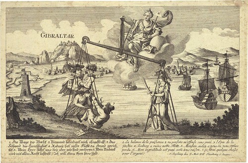
I can't quite properly comprehend all the text at the bottom of this allegorical print (dated 1782) featuring Gibraltar as the backdrop. It seems to be weighing up, I suppose, the relative virtues or intentions of nation states with a role or interest in the region; but the mention of 'Rodney' must refer to Admiral George Rodney:
"On 1 October 1779 Rodney was again appointed to command the Barbados and Leeward Islands Squadron beginning the most celebrated period of his career. He left Plymouth on 29 December 1779 with twenty ships-of-the-line, his first objective being to relieve Gibraltar. In a great piece of good fortune on 8 January 1780 his fleet sighted a twenty-two strong Spanish convoy, including seven warships of the Caracas Company. All were captured and the merchant ships became a British convoy to supply the Gibraltar garrison."
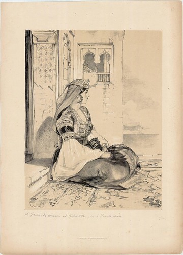
A Jewish Woman of Gibraltar in Fine Dress (1800)
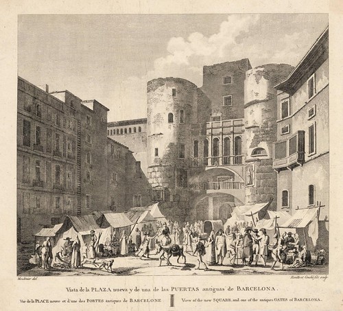
View of the New Square and one of the Antique Gates of Barcelona (~1820)
The drawing is by Jacques Moulinier and *may* have been commissioned at the beginning of the 19th century by the French writer/politician, Alexandre de Labord, who published two massive volumes on Spain that included nine hundred engravings by a host of artists. {et en français}
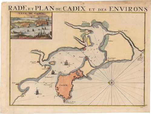
'Rade et Plan de Cadix et des Environs' (1700 - Cadiz, Spain)
[What does 'rade' mean?? A: harbour]
[
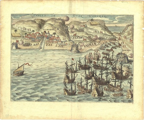
"A very busy battle scene showing Allagoena in Gran Canaria and the attack of the Dutch fleet in 1599. Ships in the foreground send smaller boats to the coast and fighting figures with their muskets raised are identifiable on the land." [source]
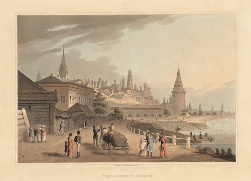
The Kremlin, Moscow (1814)
This hand coloured aquatint engraving appeared in 'An Illustrated Record of Important Events in the Annals of Europe, during the Years 1812, 1813, 1814, & 1815. Comprising a Series of Views of Paris, Moscow, the Kremlin, Dresden, Berlin, the Battles of Leipsic, etc.' by Robert Bowyer. {Christies; see also: The history of the Moscow Kremlin [homepage]}
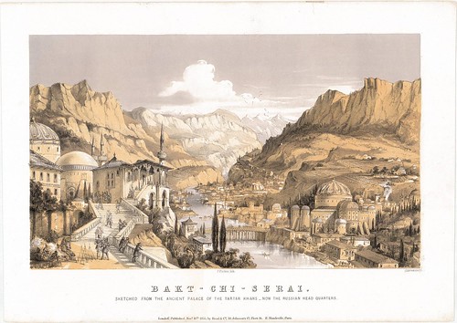
Bakt-Chi-Serai (1855) [lithography by T Packer]
"Sketched from the Ancient Palace of the Tartar Khans - Now the Russian Headquarters"[Crimea is part of Ukraine these days]
In the book, 'The Sabres of Paradise' (2004) [preview/amazon], Lesley Blanch advises that the descendants of Genghis Khan, the Krim Khans of Crimea, had a palace in their capital, Baktchiserai. The fairly austere life of the Khans meant that, although they generally eschewed worldly riches, they chose magnificent locations to live:
"The luxury of the Khan's palaces were not so much dependent on riches as on the voluptuous beauty of their setting. At Baktchiserai nightingales sang in the flowering trees; there were pearl-shell fountains and an insidious mixture of sacred and profane love, of harem and mosque."The palace became a hospital during the Crimean War (1854-1856) and is best remembered as the inspiration for Pushkin's poem, 'The Fountain of Baktchiserai': "the story of a Polish Contess and her lover, a Tartar Khan." [see also: The Crimea IN: Illustrated Description of Russia from 1855]
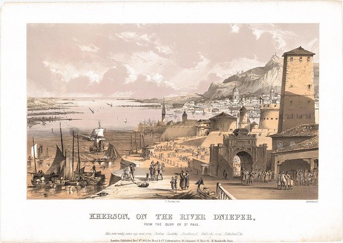
Kherson, on the River Dnieper, from the Quay of St Paul
1855 [lithography by T Packer] (Ukraine) {wikipedia}
1855 [lithography by T Packer] (Ukraine) {wikipedia}
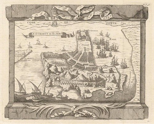
Ile Dormus ou de Jerun (~1748)
Hormuz Island (Iran) [sat-map] is situated in the Persian Gulf near the coast of Iran. About 30% of the world's oil supplies passes through the Straight of Hormuz, a stretch of water less than thirty miles wide between Iran and Oman. Consequently, it is one of the most strategically important and politically volatile waterways in the world. See the extensive dataxinfo site on Hormuz.
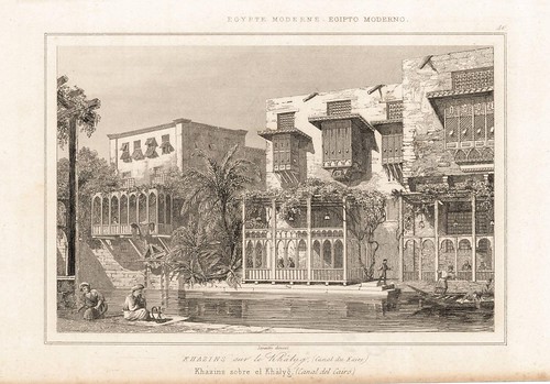
Egypte moderne: Khazins sur le Khalyg (canal du Caire)
[Cairo canal] by Lemaitre, 1821.
[Cairo canal] by Lemaitre, 1821.

The Pharos of Ptolemey King of Egypt
Engraved for the New Geographical Dictionary, 1790
Engraved for the New Geographical Dictionary, 1790
Built in the 3rd century BC at the order of King Ptolemy I, the 400-450 ft. Lighthouse of Alexandria (one of the seven ancient wonders of the world) was severely damaged by earthquakes in the 14th century and the ruins incorporated into a fort built on the same site. Remnants of the lighthouse stonework are visible if you go scuba diving in Alexandria's Eastern Harbour.

The Temple of the Sun in Nineveh
Engraved for the New Geographical Dictionary, 1790
Engraved for the New Geographical Dictionary, 1790
Nineveh was/is located adjacent to the present-day city of Mosul in Northern Iraq. It was said to have been a magnificent capital city of the ancient Assyrian Empire. Vast palace structures were discovered in the 19th century and their contents have of course been serially plundered by the upstanding keepers of the world's cultural institutions ever since. [one, two, three]

The Colossus of Rhodes
Engraved for the New Geographical Dictionary, 1790
Engraved for the New Geographical Dictionary, 1790
Another of the seven wonders of the ancient world, the Colossus of Rhodes was built on the island of Rhodes in Greece in the 3rd century BC. The ~100 ft. structure was made of marble, brass and bronze and it's fairly unlikely it straddled a waterway, as legend records it. An earthquake destroyed the monument less than sixty years after it was completed.
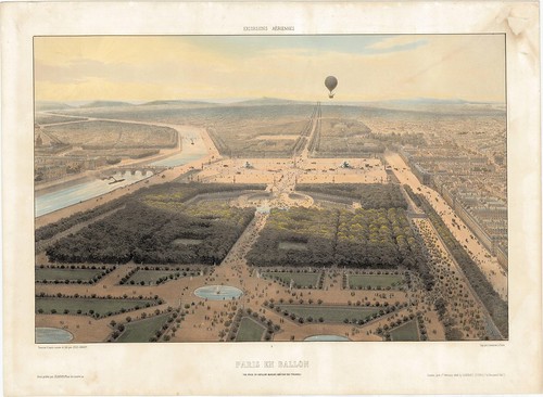
Excursions aériennes. Paris en ballon
Vue Prise du Pavillon Marsan (Château des Tuileries)
by Jules Arnout, 1846
Arnout seems to have done a series of tinted lithographs of panoramic views from a hot air balloon in (at least) France and England although I didn't discover too much searching. [for instance]Vue Prise du Pavillon Marsan (Château des Tuileries)
by Jules Arnout, 1846
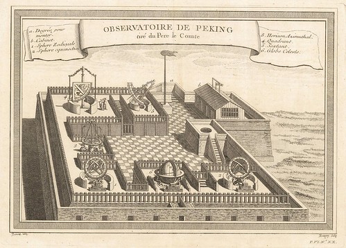
Observatoire de Peking tiré du Pere le Comte
"Showing globes, astrolabes and armillary spheres. The Peking Observatory was equipped by Ferdinand Verbiest, a Flemish Jesuit missionary in Peking in the late 1660s. Rather than building the latest models he worked from Tycho Brahe's 'Mechanica', published eighty years before." [source]
The Beijing Ancient Observatory was actually built in 1442, making it one of the oldest observatories in the world. [flickr]
Each month or so, Xavier from the French site, Lexilogos, sends out an email notice advising of the new resource sites he has added to his extensive catalogue of useful internet destinations. While the main interest of Lexilogos is language related material, Xavier also happens to find and collate links to a wide variety of subjects, and I'm always interested to see the latest maps (mostly of the antique variety) and manuscripts he has found.
This month I was directed to an excellent site, the Institut Cartogràfic de Catalunya in Spain (there's a button for english there somewhere). The images above were drawn from the 'Place views of Catalunya and the world' (16th to 20th centuries) section which has over nine hundred birds-eye view perspectives, scenic engravings and lithographs and the occasional map, relating to a host of European, North African and Asian locations. I think the selection above ought to give a fair indication of the eclectic nature of their catalogue. Spanish places only make up about 30 percent of the total, at a guess. It's definitely worth having a wander.
All of the images above were cleaned up to one extent or another. I'm *assuming* they look alright. This is something of a 'blind' post: for my video crimes against bandwidth my ISP has throttled me back to dial-up speed (again) for the next couple of days so I can't properly load either this site or the flickr page. It took a couple of hours just to upload the images. Irony, meet my soft derrière. Ouch.


5 comments :
Your posts are, consistently, astonishingly beautiful and awe-inspiring--incredible work, thank you doing this/bringing it to us/having the superb eye that you do...
"rade" means "harbour".
Thank you and keep going!
The Gibraltar print says:
1. The balance of power
2. Nobody offends me without punishment
3. The sword of justice
4. Rodney made our fleet ruin
5. My Lord, stay with me otherwise we are lost
6. My ingratitude will be punished with all the laws
7. I want to do something for money
Ralf
Cheers!
And thanks for the translation Ralf. Part of the trouble of course is trying interpret those words against the contemporary events and people depicted.
Dear Madelaine (also known as Chrissy)
I have deleted your comment.
You are free to make any on-topic comment you wish. You are not free to add a link to any site unless it is relevant to the post/discussion. Thanks.
Post a Comment
Comments are all moderated so don't waste your time spamming: they will never show up.
If you include ANY links that aren't pertinent to the blog post or discussion they will be deleted and a rash will break out in your underwear.
Also: please play the ball and not the person.
Note: only a member of this blog may post a comment.