'The Illustration of The Great European War No.16
- A humoros Atlas of the World'
- A humoros Atlas of the World'
+India.jpg)
+China.jpg)
+Western+Europe.jpg)
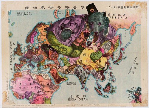
It's tempting, finding this caricature map among a collection of propaganda prints relating to the Chinese Revolution of 1911/1912, to overstate the possible subtextual commentary on contemporary events in China.
The map was actually published in Japan in 1914 and the Japanese script is faithfully - apart from some misspellings - rendered into English with the correct dual names and also title added at the bottom of the print.
So, although the China-as-pig figure is seen examining the Manchurian lands of the former Qing Dynasty (ousted in the revolution to be replaced by the early form of the Republic of China) through a magnifying glass (or barometer, as the text apparently implies), it's hard to deduce any strong editorial meaning in the illustration.
Perhaps there is some suggestion that China was too busy smoothing out its own problems to take notice of the rest of the world being on the verge of war? Or that the agriculture-based society had little impact outside its own borders? The complicated series of circumstances that gave rise to the revolution included a sense that foreign powers had too much influence in China together with an emerging desire for a republic similar to America (in many minds), so there may be some measure of irony buried in the imagery.
But the print's title and detailed caricatures across the rest of the world point to the author/illustrator (Tanaka) employing a wider-angled lens, with the focus going far beyond China or Asia. There is a lot to see in the map, not only because it depicts the start of World War I from a satirical standpoint, but because the views being expressed are coming out of Japan/Asia.
My favourite parts are the tusked wart-hog of Germany, the semi-sea monster appearance of Britain (perhaps inspired by Gillray's 1790 cartoon map [see also: Robert Dighton's 1795 map]) and the stitch work appearance for some of the borders, suggesting impermanence.
Somewhat similar maps previously: The Paul Hadol 1870 caricature map of Europe [down the page] (and his 1877 octopus map); William Harvey's 1868 'Geographical Fun' and the 1899 'Angling in Troubled Water' map by Fred Rose.
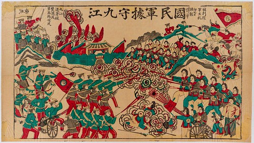
All images in this post come from: 'Block Prints of the Chinese Revolution' at Princeton University -
"A collection of 30 poster-like block prints of the 1911 Chinese Revolution given to Princeton University East Asian Library by Donald Roberts, class of 1909. The collection is useful for investigations into the visual portrayal of the struggle of Han Chinese versus the Manchus during the 1911 overthrow of the Qing Empire, with issues of "modernity" and "nation" easily visible."
- 1911 Revolution in Chinese History by Richard Hooker.
- Xinhai Revolution at Wikipedia.
- 'Sun Yat-sen's 1911 Revolution had Its Seeds in Tokyo' by Sato Kazuo at Japan Focus.
- 'Great Awakening of Chinese Nation-Marking' - the China Peoples Daily on the 90th anniversary of the 1911 revolution.
- 1911 Revolution map at Unimaps.
- Very tangential: 'Living in the Chinese Cosmos - Understanding Religion in Late Imperial China (1644-1911)' - web exhibition site at Columbia University.
- Stefan Landberger's comprehensive Chinese Propaganda Poster Pages.
- My sincere thanks to Jim Weldon and Jonathan Dresner for their advice.
+Xinhai+Revolution+1911.jpg)


2 comments :
One thing that particularly catches my attention is that the color division of the French tiger and its hat is a pretty good approximation of the culturally-distinct region of Occitania. If that was intentional, this is an unusually careful caricature map!
Anthropomorphic Maps and the Human Shape of the Holy Land
http://www.holylandmap.net/anthro/enanthroindex.html
Post a Comment
Comments are all moderated so don't waste your time spamming: they will never show up.
If you include ANY links that aren't pertinent to the blog post or discussion they will be deleted and a rash will break out in your underwear.
Also: please play the ball and not the person.
Note: only a member of this blog may post a comment.