"John Speed’s Theatre of the Empire of Great Britaine is one of the world’s great cartographic treasures. Published in 1611/12, it marked the first time that comprehensive plans of English and Welsh counties and towns were made available in print. [..]
A slice of Tudor and Jacobean life in miniature, its influence was so great that it was used by armies on both sides of the English Civil War. [..]
The county maps were the first consistent attempt to show territorial divisions, but it was Speed’s town plans that were a major innovation and probably his greatest contribution to British cartography. Together, they formed the first printed collection of town plans of the British Isles and, for at least 50 of the 73 included in the Theatre, it was the first time these towns had been mapped."
[source]
A selection of the very rare hand-coloured proofs for the Speed atlas, produced between 1603 and 1611, is seen below. The collection of proofs was digitised recently by its owner, Cambridge University Library and prints of the maps are for sale.
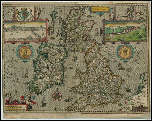
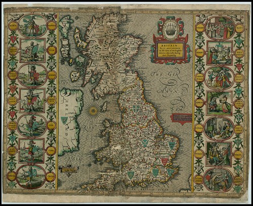
The Kingdome of Great Britaine & Ireland
Graven by I. Hondius and are able to be ſolde by I Sudbury and George Humble in Popes head Alley in London. Cum privilego Regis 1610
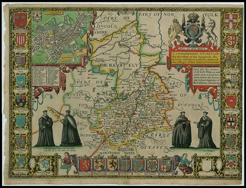
Cambridgeshire
Cambridgshire deſcribed with the deviſion of the hundreds, the Townes ſituation, with the Armes of the Colleges of that famous Vniuerſiti. And alſo the Armes of all ſuch Princes and noble men as haue heertofore borne the honorable tytles & dignities of the Earldome of Cambridg.
"This province is not large, nor the air greatly to be liked, having the Fenns so spread upon her North, that they infect the air far into the rest. The soil doth differ both in air and commodities; the Fenny surcharged with waters: the South is Champion, and yieldeth Corn in abundance, with Meadow-pastures upon both sides of the River Came."
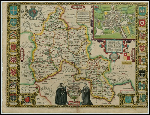
Oxfordshire
Oxfordshire deſcribed with (every?) Citie and the Armes of the Colledges of (theyre?) famous Vniuerſity. Ao. 1605.
Performed by John Speede and are to beſold in popes head alley against the Exchange by IS & GH Cum Privilegio.
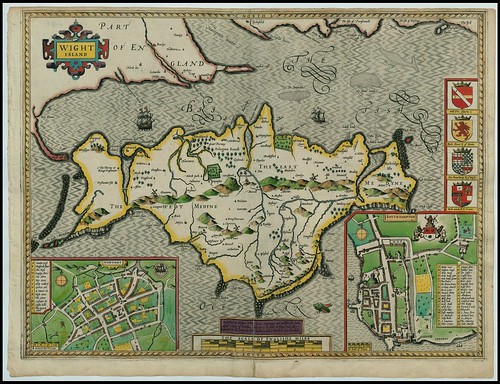
Wight Island
Deſcribed by William White Gent. Augmented and publiſhed by John Speed Citizen of London.
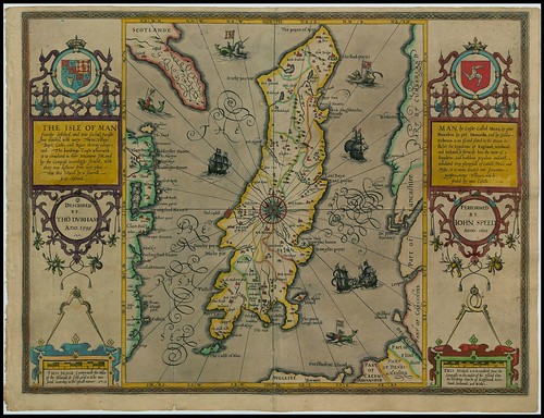
The Isle of Man
THE ISLE OF MAN Exactly deſcribed, and into ſeveral Pariſhes diuided, with euery Towne, Village, Baye, Creke, and Riuer therein conteyned. The bordringe Coaſts wherewith it is circulated in their situations ſett, and by the Compaſe accordingly ſhewed, with their true diſtance from euery place unto this Island by a ſeuerall scale obſerued.
MAN by Caeſar called Mona, by plini Monabia, by ptol. Monoceda, and by Gildas Evbonia is an Iſland ſeated in the Ocean betwixt the kingdomes of England, Scotland and Ireland, it formerly bare the name of a kingdome, and hathbene populous and well inhabited very plentyfull of Cattell, Foule and Fyſhe, it is nowe deuided into ſeauentene pariſhes, many Villages, and defended by twoe Caſtells.
THIS SCALE Conteyneth the Miles of the Iſland, it ſelfe, and is to be meaſured according the vſuall manner
PERFORMED BY IOHN SPEED Anno. 1605
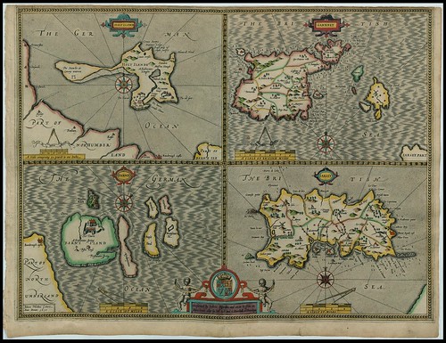
Holy Island, Garnsey, Farne Island, Iarsey
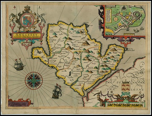
Angelsey [Wales]
Antiently called Mona. Deſcribed 1608
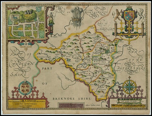
Radnorshire [Wales]
The Countie of RADNOR described and the shyretownes sittuatione Anno 1608.
Deſcribed by ChriStopher Saxon, Augmented and publiſhed by Iohn Speede Servant to his Majeſty.
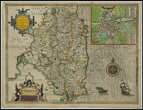
Leinster [Ireland]
The Countie of LEINSTER with the Citie DUBLIN Deſcribed
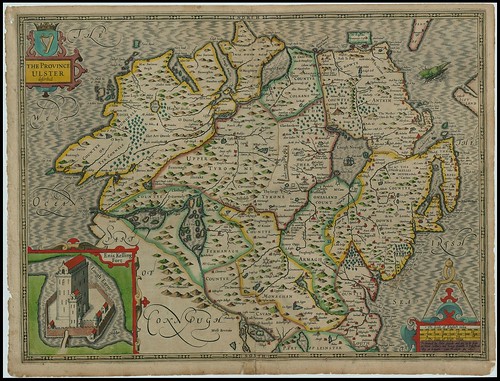
Ulster [Ireland]
The Province of ULSTER deſcribed
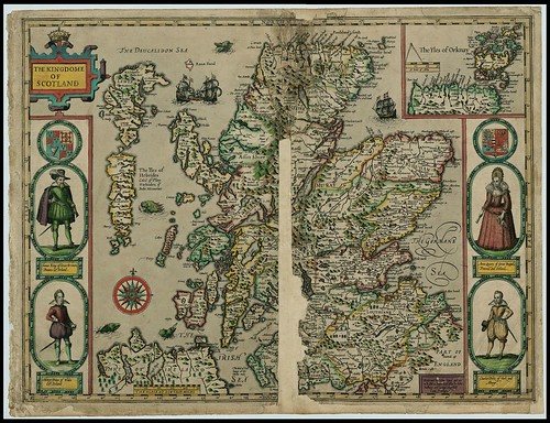
The Kingdome of Scotland
[including the]
Yles of Hebrides Caled of Pliny Haebudes, of Beda Meuaniae
[and the]
Yles of Orknay
Yles of Hebrides Caled of Pliny Haebudes, of Beda Meuaniae
[and the]
Yles of Orknay
Britain
As it was devided in the tyme of the Enghſhe (?) Saxons eſpecially during their Heptarchy
{All images were spliced together from screencaps; click through to greatly enlarged versions}
The John Speed proof maps (66 in total) were printed by Jodocus Hondius in Amsterdam. {Individual prints of the maps are available for purchase from Cambridge University}
Mapping the origins of a masterpiece.
Map Forum biography of John Speed [W].